WaterWays

Overview
Introduction
Our team was presented with this project from our client, Noble Falconer. Noble had identified an area of opportunity in providing information about water resources. Drawing from his personal experience, Noble recognized that there isn’t a digital tool to help individuals locate natural water sources. Instead, individuals must rely upon local knowledge, or the knowledge of friends and family, to discover water sources. With this in mind, Noble presented the problem to our team. We then worked to discover what kind of tool could help in this particular area.
Challenge
Our challenge was to meet the needs of our client in addition to the needs of our users. We started with the need as addressed by our client, and expanded upon it slightly. Another challenge was developing the overall tone of the application, and considering how to best engage our user base. Knowing that our users would be primarily outdoor enthusiasts, we worked to create a voice of respect for the community and the environment.
The Solution
Upon conducting research through surveying users, doing a competitive analysis of similar applications and several rounds of evaluations, we worked towards meeting our users needs through the design and development of our WaterWays mobile application. WaterWays allows users to discover water sources within a given area, and also allows users to add in new water sources.
Methods & Tools
Competitive & Comparative Audit | Survey | Journey Mapping | Personas | Participant Observation | Evaluative Interviews | Usability Testing | Figma
Personal Reflection
Throughout this project, one of my main areas of interest was within the research and understanding the user’s needs. We needed to provide a platform with information, but also curate a community of responsible users. We recognized that part of our development of the app required attention to how users would utilize the app, and what type of message WaterWays would embody.
Client & Users
The Client
Our client, Noble Falconer, is an individual who had knowledge of high quality water sources in his area, particularly knowledge about artesian wells. Artesian wells source some of the purest water available, but Noble saw that there was no platform for individuals to share information about the location of artesian wells. Instead, individuals had to rely upon local knowledge or connections with friends and family to discover such high-quality water sources. Seeing this as an opportunity to provide a tool to users, Noble came to us with this unique concept.
The Users
For this project, Noble suggested that individuals interested in sourcing water from artesian wells would be part of our user group. He also indicated that he imagine outdoor enthusiasts, such as hikers and campers, would be part of the main user group. We conducted research, and found that our users were predominantly hikers, campers and eco-conscious individuals. We took this information into consideration, and based our design decisions upon their needs.
The User’s Goals
Our user’s goals for this project were to discover potable water sources near them and to add in new water sources. After confirming that our users were predominantly outdoor enthusiasts, we determined that their goals would be to find reliable water sources and provide information about those sources if they wished to do so.
The Process
Research
We began to explore the process through discovery research to understand the particular problem along with the users. Our methods of research included surveys, comparative and competitive audits of existing websites and apps, participant observation, evaluative interviews, and usability tests.
Discovering the Users
To understand our users, we sent out a survey to groups of individuals who participate in outdoor activities. Water is a large component of remaining healthy, especially if someone is regularly active in the outdoors, and we wanted to get a sense of how people supply their water. Our users reported that they are impacted by water supplies, and that they also regularly rely upon mobile devices for their activities.
Key Findings


Research & Findings Report
Discovering What Exists
In order to understand the problem, we needed to understand what currently exists in the digital space to provide users with information about natural water sources. We looked at a variety of websites and online resources to discover what information is accessible to the general public. One website we referenced was FindASpring.com. However, one of the large problems with this site was its outdated appearance and lack of user-generated information. Overall, despite its ability to provide users with information on where springs are located, the website seemed somewhat abandoned and untrustworthy.
We also examined public information that was available through the Minnesota Department of Natural Resources. The Minnesota DNR has a spring inventory project that is a database of information on springs generated by the public. Users can download an app provided by the Minnesota DNR, and log springs around the state of Minnesota. The DNR reviews each submission to ensure that the data is accurate; however, they do not confirm each submission in the field. Additionally, an employee with the DNR indicated that no one should assume these springs are potable. Instead, he stressed that the water at these springs should be properly filtered before human consumption.

After gathering this information, it was clear to us that we needed to ensure that our design was only for potable water sources. We recognized that part of our design would need to involve curating a community of responsible users that would encourage engagement and allow users to report any issues with a water source if one were to arise.
Discovering Common Patterns
Part of understanding how to design our own application was to examine applications that operate similarly by wayfinding specific points upon a map. Several applications that we looked at for comparison included AllTrails, The Dyrt, Geocaching and FindTap. After seeing common UI patterns within these designs, we began to incorporate this into our first round of wireframes. When we presented the wireframes to users for a first round of evaluative interviews, users responded positively, stating that the UI for WaterWays was already familiar to them from using similar applications.
Screenshots from AllTrails, Geocaching, and TheDyrt are included below:


Personas + Journey Mapping
In order to help guide our design decisions, we developed 2 personas and user journey maps to understand the experiences of a user. Our personas were developed out of the surveys that we conducted, and allowed us the ability to externalize our thoughts on how a user might use our application.


Wireframes & Evaluation Reviews
As we gathered data, we also needed to determine if our direction aligned with user needs. We developed a series of wireframes to show some of the key flows within the application, specifically those involving finding a water source, adding a water source, and reporting an issue. After we developed this, we presented the wireframes to users to get their reactions to the design as well as the concept.
Our test reviewers responded positively to the overall concept and acknowledged that they could see themselves using such an application while participating in outdoor activities. Users provided us with feedback with some of the overall design, indicating that they saw the application as less of a social media platform and more of an informative tool.
A significant part of wireframing was identifying the information architecture of the application. We identified the main tasks that a user would need to complete, and then developed the IA for the application itself.


Participant Observation
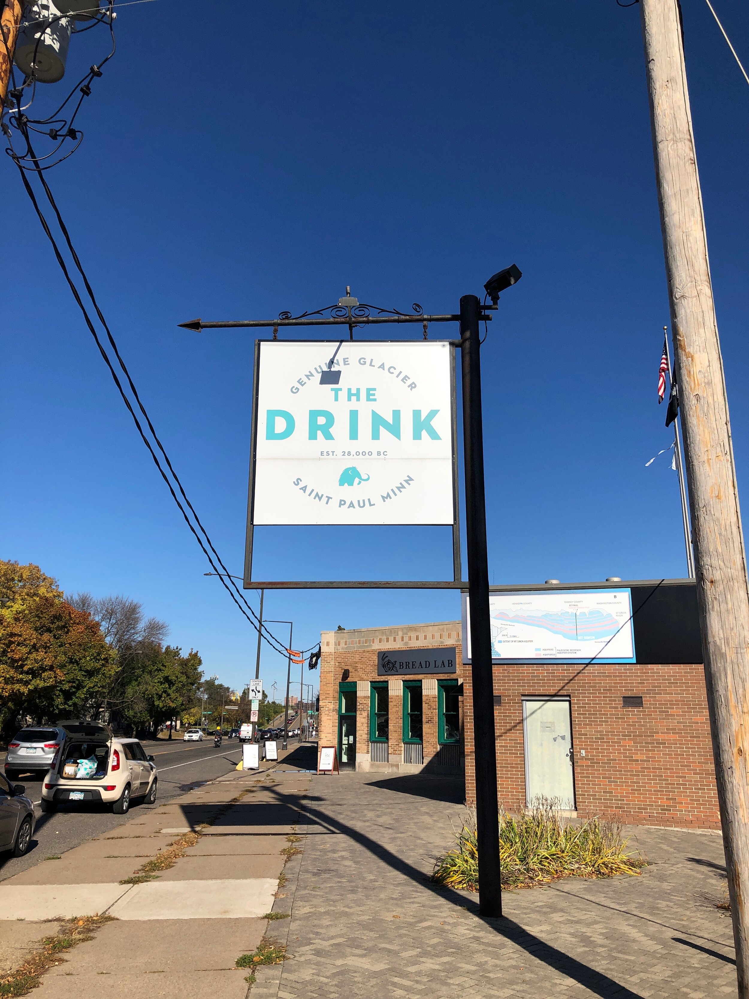
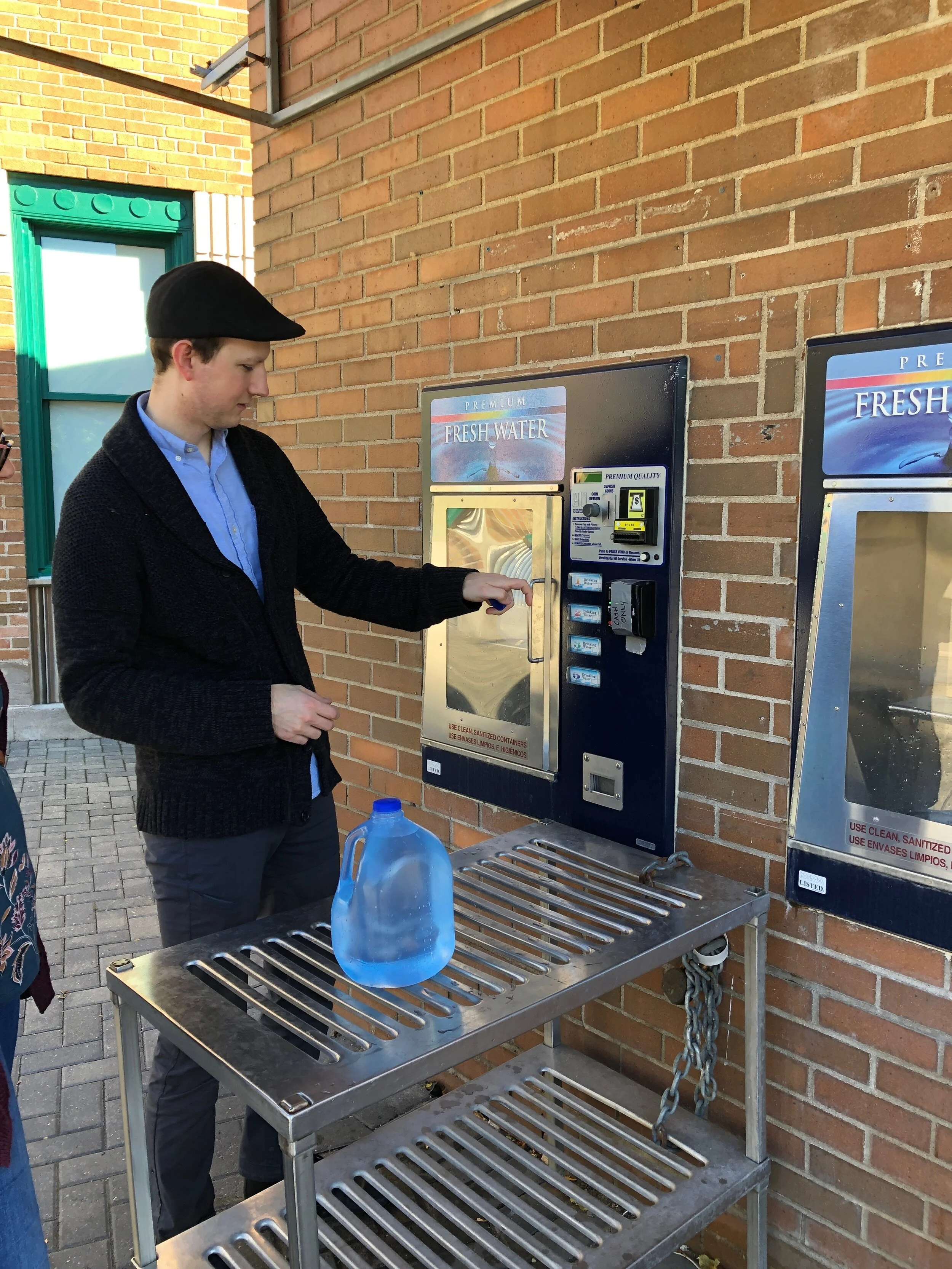
To experience sourcing water from a local well, we visited nearby wells in the St. Paul / Minneapolis area. At each location, we observed the behaviors of individuals who were visiting to get their water. A majority came prepared with multiple jugs and containers to hold their water. It was evident that these sources supplied a need for nearby citizens, and receive regular visitors. Additionally, we observed what each area was like, such as whether or not the location was on a road or if the location required payment. All of this information informed our design decisions as we developed our prototype.
The Drink, St. Paul, MN

The Fredrick-Miller Spring, Eden Prairie, MN


The Solution

For our final design, we developed the mobile application called WaterWays. The WaterWays application is intended to be a helpful resource to a variety of individuals who participate in outdoor recreation. The main features of WaterWays involve the following:
Search for water sources
View details about a water source
Review user comments & activity at a water source
Discover water sources along a route
Locate water sources along a hiking trail
Save information for offline viewing
Annotated Wireframes


Design Assets

Interactive Prototype
Final Thoughts
Conclusion
The unique concept of WaterWays can fulfill the needs of a niche yet highly engaged user group. Individuals who participate in outdoor activities need to rely upon potable water sources as a means to stay adequately hydrated. With users reporting that they would feel relieved to know where water sources are in a particular area, it is evident that WaterWays is a viable application that has the potential to evolve into a reliable outdoor recreation tool.
Next Steps
The partnership opportunities that exist for WaterWays are innumerable, and could range from outdoor-focused brands to adventure companies on a local and national level. It’s recommended that WaterWays begin to develop relationships with local outdoor-based companies and brands as a way to gain exposure for the platform. By beginning adoption for the platform at a local level, WaterWays can then begin to expand and grow into a larger market across the nation.
In addition to outdoor organizations, there is also the opportunity for WaterWays to partner with existing applications, such as AllTrails or TheDyrt. By discovering other applications that provide related services (such as hiking trails or camping sites), WaterWays can explore new potential for reaching its user base. Through intentional partnerships with key companies and brands, there is only one pathway for WaterWays, and that is the pathway of growth.